


Le fort de Joux n°80

cmike39
User

Length
22 km

Max alt
1020 m

Uphill gradient
548 m
Km-Effort
30 km

Min alt
831 m

Downhill gradient
549 m
Boucle
Yes
Creation date :
2023-01-24 13:07:00.22
Updated on :
2023-01-24 13:24:31.593
6h44
Difficulty : Very difficult

FREE GPS app for hiking
 SityTrail
IGN / Geographical institutes
SityTrail Plus
The world is yours!
About
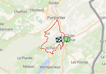
Trail Walking of 22 km to be discovered at Bourgogne-Franche-Comté, Doubs, La Cluse-et-Mijoux. This trail is proposed by cmike39.
Points of interest


Positioning
Country:
France
Region :
Bourgogne-Franche-Comté
Department/Province :
Doubs
Municipality :
La Cluse-et-Mijoux
Location:
Unknown
Start:(Dec)
Start:(UTM)
299590 ; 5192801 (32T) N.
Comments